Blog Options
Archive
<< April 2026 >>-
Thursday 2
- TMS Smart Setup v3.1 brings Delphi 13.1 Arm64EC support to TMS products—and raises the bar for the Delphi ecosystem
Authors
- Bernard Roussely (3)
- Wagner Landgraf (98)
- Dennis Röhner (1)
- Roman Yankovsky (2)
- Bart Holvoet (42)
- Aaron Decramer (83)
- Pieter Scheldeman (136)
- Nancy Lescouhier (32)
- Adrian Gallero (34)
- Bruno Fierens (452)
- Marcos Douglas B. Santos (5)
- Bernard (4)
- Bradley Velghe (36)
- Andrew Simard (86)
- Holger Flick (15)
- Gjalt Vanhouwaert (44)
- Tunde Keller (37)
- Masiha Zemarai (117)
Blog
All Blog Posts | Next Post | Previous Post

 The TMS WebGMaps v3.1 update includes map styles and SVG markers
Monday, April 29, 2019
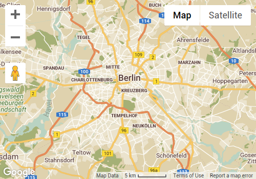
We're pleased to announce TMS WebGMaps v3.1 has been released today. TMS VCL WebGMaps is our component for VCL development that exposes a myriad of geographical functions for integration in Delphi or C++Builder Windows applications while TMS FMX WebGMaps offers the same functionality for cross-platform FireMonkey applications on Windows, Mac, iOS and Android.In this new version we introduce the functionality to display the map in a custom style. You can use the pre-defined Night Mode style or any other custom style.
The code needed for this is just one line of code:
WebGMaps1.MapOptions.MapStyle := mstNightMode;
The code needed for this is just two lines of code:
  WebGMaps1.MapOptions.CustomStyle.Text := '[JSON Object]';
  WebGMaps1.MapOptions.MapStyle := mstCustom;
Use the Google Maps Platform Styling Wizard as a quick way to generate your own JSON styling object.
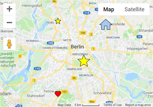
Another new feature are SVG Markers. This technique allows to display markers with a custom shape based on a SVG path. Several pre-defined shapes are available as well as the possibility to add your own custom SVG path.
Adding markers with a custom shape is very easy as this code snippet shows:
var
  m: TMarker;
begin
  m := WebGMaps1.Markers.Add(WebGMaps1.MapOptions.DefaultLatitude, WebGMaps1.MapOptions.DefaultLongitude);
  m.Shape := msStar;
  m.ShapeColor := clYellow;
  m.ShapeScale := 2;
  WebGMaps1.UpdateMapMarker(m);

  m := WebGMaps1.Markers.Add(WebGMaps1.MapOptions.DefaultLatitude + 0.1, WebGMaps1.MapOptions.DefaultLongitude - 0.1);
  m.Shape := msStar;
  m.ShapeColor := clYellow;
  WebGMaps1.UpdateMapMarker(m);

  m := WebGMaps1.Markers.Add(WebGMaps1.MapOptions.DefaultLatitude - 0.1, WebGMaps1.MapOptions.DefaultLongitude - 0.1);
  m.Shape := msFavorite;
  WebGMaps1.UpdateMapMarker(m);

  m := WebGMaps1.Markers.Add(WebGMaps1.MapOptions.DefaultLatitude + 0.1, WebGMaps1.MapOptions.DefaultLongitude + 0.1);
  m.Shape := msHome;
  m.ShapeColor := clSkyBlue;
  m.ShapeScale := 2;
  WebGMaps1.UpdateMapMarker(m);
end;
Today's update also includes other smaller new features and improvements.
We look forward to learn about your interesting integrations of TMS WebGMaps in your applications!
Bart Holvoet

This blog post has not received any comments yet.
All Blog Posts | Next Post | Previous Post